
Rio Maior topographic map
Interactive map
Click on the map to display elevation.
About this map
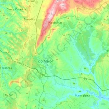
Name: Rio Maior topographic map, elevation, terrain.
Location: Rio Maior, Santarém, Lezíria do Tejo, Alentejo, Portugal (39.23491 -9.00157 39.46601 -8.78307)
Average elevation: 129 m
Minimum elevation: 5 m
Maximum elevation: 494 m
Other topographic maps
Click on a map to view its topography, its elevation and its terrain.
Alcaria Ruiva
Portugal > Alentejo > Mértola > Alcaria Ruiva
Alcaria Ruiva, Mértola, Alcaria Ruiva, Beja, Baixo Alentejo, Alentejo, Portugal
Average elevation: 195 m
Alcácer do Sal
Alcácer do Sal, Setúbal, Alentejo Litoral, Alentejo, Portugal
Average elevation: 77 m
Portalegre
Portugal > Alentejo > Portalegre
Portalegre, Alto Alentejo, Alentejo, 7300-139, Portugal
Average elevation: 416 m
Caneja
Portugal > Alentejo > Boavista dos Pinheiros
Caneja, Boavista dos Pinheiros, Odemira, Beja, Alentejo Litoral, Alentejo, 7630-171, Portugal
Average elevation: 35 m