
Weatherly topographic map
Interactive map
Click on the map to display elevation.
About this map
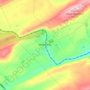
Name: Weatherly topographic map, elevation, terrain.
Location: Weatherly, Carbon County, Pennsylvania, 18255, United States (40.92964 -75.85219 40.95340 -75.78938)
Average elevation: 406 m
Minimum elevation: 290 m
Maximum elevation: 533 m
Weatherly is located in northwestern Carbon County at 40°56′25″N 75°49′36″W / 40.94028°N 75.82667°W / 40.94028; -75.82667 (40.940257, -75.826722). It is situated at an elevation of 1,100 feet (340 m) above sea level in the Ridge-and-Valley Province of the Appalachian Mountains, between Spring Mountain and Round Head Mountain to the north and Broad Mountain to the south.
Other topographic maps
Click on a map to view its topography, its elevation and its terrain.
Penn Forest Township
United States > Pennsylvania > Carbon County > Penn Forest Township
Penn Forest Township, Carbon County, Pennsylvania, 18210, United States
Average elevation: 407 m