
Marávia topographic map
Interactive map
Click on the map to display elevation.
About this map
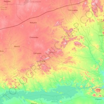
Name: Marávia topographic map, elevation, terrain.
Location: Marávia, Provinz Tete, Mosambik (-15.69790 31.34889 -14.34789 32.98851)
Average elevation: 727 m
Minimum elevation: 274 m
Maximum elevation: 1,475 m
Maravia ist hügelig mit einer Höhenlage zwischen 300 und 1.000 Meter, die bekanntesten Berge sind der Chiputu (1.502 m), der Chuamba (1.335 m) und der Camessongue (1.450 m). Der Hauptfluss ist der Sambesi. Weitere wichtige Flüsse sind Capoche, Unkanha, Luatize und der Duanga Mucumbudzi.
Other topographic maps
Click on a map to view its topography, its elevation and its terrain.