
Thank you for supporting this site ❤️
Make a donation
Make a donation
Tyrol topographic map
Click on the map to display elevation.
Thank you for supporting this site ❤️
Make a donation
Make a donation
About this map
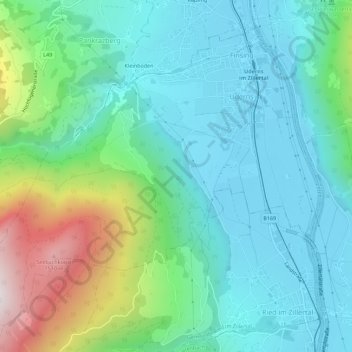
Name: Tyrol topographic map, elevation, terrain.
Location: Tyrol, 6271, Austria (47.29824 11.82006 47.33033 11.87581)
Average elevation: 794 m
Minimum elevation: 538 m
Maximum elevation: 1,592 m
Thank you for supporting this site ❤️
Make a donation
Make a donation
Other topographic maps
Click on a map to view its topography, its elevation and its terrain.