
McCreary County topographic map
Interactive map
Click on the map to display elevation.
About this map
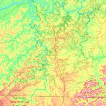
Name: McCreary County topographic map, elevation, terrain.
Location: McCreary County, Kentucky, Vereinigte Staaten von Amerika (36.59188 -84.77861 36.96257 -84.22866)
Average elevation: 349 m
Minimum elevation: 197 m
Maximum elevation: 650 m
Other topographic maps
Click on a map to view its topography, its elevation and its terrain.
Stearns
Vereinigte Staaten von Amerika > Kentucky > McCreary County
Stearns, McCreary County, Kentucky, Vereinigte Staaten von Amerika
Average elevation: 392 m