
Thank you for supporting this site ❤️
Make a donation
Make a donation
Morgan Lewis topographic map
Click on the map to display elevation.
Thank you for supporting this site ❤️
Make a donation
Make a donation
About this map
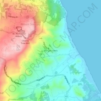
Name: Morgan Lewis topographic map, elevation, terrain.
Location: Morgan Lewis, Saint Andrew, BB25001, Barbados (13.24871 -59.59463 13.28871 -59.55463)
Average elevation: 81 m
Minimum elevation: -1 m
Maximum elevation: 252 m
Thank you for supporting this site ❤️
Make a donation
Make a donation