
Make a donation
Tenafly topographic map
Click on the map to display elevation.
Make a donation
Tenafly
Tenafly's street plan and overall development were largely determined by its hills and valleys. The eastern part of the borough is referred to as the "East Hill" for its higher elevation in relation to the rest of the borough. There, the terrain rises dramatically to the east of the downtown area, terminating at the New Jersey Palisades, overlooking the Hudson River. Nearby is the Tenafly Nature Center, located at 313 Hudson Avenue.
Make a donation
About this map
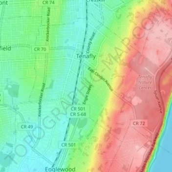
Name: Tenafly topographic map, elevation, terrain.
Location: Tenafly, Bergen County, New Jersey, 07670, United States (40.89549 -73.98443 40.93791 -73.91894)
Average elevation: 57 m
Minimum elevation: 0 m
Maximum elevation: 140 m
Make a donation
Other topographic maps
Click on a map to view its topography, its elevation and its terrain.
Make a donation
Make a donation
Make a donation
Make a donation
Ridgefield Park
United States > New Jersey > Bergen County > Ridgefield Park > Ridgefield Park
Average elevation: 21 m
Make a donation