
Buriatia topographic map
Interactive map
Click on the map to display elevation.
About this map
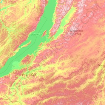
Name: Buriatia topographic map, elevation, terrain.
Location: Buriatia, Distrito federal de Siberia, Rusia (50.15824 106.93214 55.27824 112.05214)
Average elevation: 965 m
Minimum elevation: 422 m
Maximum elevation: 2,546 m
Other topographic maps
Click on a map to view its topography, its elevation and its terrain.
Бриг
Rusia > Buriatia > сельское поселение Аршан
Бриг, сельское поселение Аршан, Тункинский район, Buriatia, Distrito federal de Siberia, Rusia
Average elevation: 2,106 m
Витим
Rusia > Buriatia > Муйская сельская администрация
Витим, Муйская сельская администрация, Муйский район, Buriatia, Distrito federal de Siberia, Rusia
Average elevation: 480 m