
Republic of Karelia topographic map
Interactive map
Click on the map to display elevation.
About this map
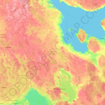
Name: Republic of Karelia topographic map, elevation, terrain.
Location: Republic of Karelia, Northwestern Federal District, Russia (60.68051 29.30618 66.66732 37.94664)
Average elevation: 113 m
Minimum elevation: -3 m
Maximum elevation: 514 m
Other topographic maps
Click on a map to view its topography, its elevation and its terrain.
Чапари
Russia > Republic of Karelia > Муезерское городское поселение
Чапари, Муезерское городское поселение, Muyezersky District, Republic of Karelia, Northwestern Federal District, Russia
Average elevation: 169 m
Чола
Russia > Republic of Karelia > Валдайское сельское поселение
Чола, Валдайское сельское поселение, Segezhsky District, Republic of Karelia, Northwestern Federal District, Russia
Average elevation: 169 m
Yuzhnyy Oleniy Island
Russia > Republic of Karelia > Великогубское сельское поселение
Yuzhnyy Oleniy Island, Великогубское сельское поселение, Medvezhyegorsky District, Republic of Karelia, Northwestern Federal District, Russia
Average elevation: 37 m