
Thank you for supporting this site ❤️
Make a donation
Make a donation
Llanddewi Brefi topographic map
Click on the map to display elevation.
Thank you for supporting this site ❤️
Make a donation
Make a donation
About this map
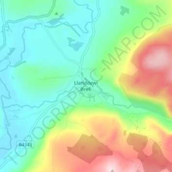
Name: Llanddewi Brefi topographic map, elevation, terrain.
Location: Llanddewi Brefi, Ceredigion, Wales, SY25 6RS, United Kingdom (52.15979 -3.97743 52.19979 -3.93743)
Average elevation: 241 m
Minimum elevation: 134 m
Maximum elevation: 457 m
Thank you for supporting this site ❤️
Make a donation
Make a donation
Other topographic maps
Click on a map to view its topography, its elevation and its terrain.
Newcastle Emlyn Castle
United Kingdom > Wales > Ceredigion > Adpar > Bryndioddef
Average elevation: 78 m
Thank you for supporting this site ❤️
Make a donation
Make a donation
Thank you for supporting this site ❤️
Make a donation
Make a donation
Thank you for supporting this site ❤️
Make a donation
Make a donation
Thank you for supporting this site ❤️
Make a donation
Make a donation