
Thank you for supporting this site ❤️
Make a donation
Make a donation
El Huaco topographic map
Click on the map to display elevation.
Thank you for supporting this site ❤️
Make a donation
Make a donation
About this map
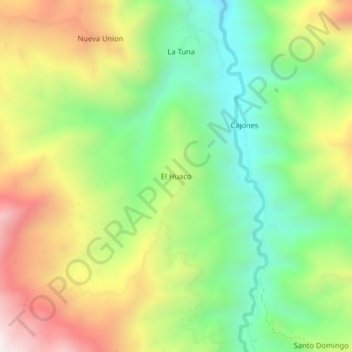
Name: El Huaco topographic map, elevation, terrain.
Location: El Huaco, San José del Alto, Jaén, Cajamarca, Perú (-5.57679 -78.99311 -5.53679 -78.95311)
Average elevation: 1,565 m
Minimum elevation: 1,167 m
Maximum elevation: 2,109 m
Thank you for supporting this site ❤️
Make a donation
Make a donation
Other topographic maps
Click on a map to view its topography, its elevation and its terrain.