
Make a donation
Mangalia topographic map
Click on the map to display elevation.
Make a donation
Mangalia
Mangalia is positioned at 43°49’ latitude and 28°35’ longitude, with an approximate elevation of 10 meters, 44 kilometres (27 miles) south of the municipality of Constanţa, on the same latitude as the French resort of Nice. Mangalia is one of the southernmost resorts on the Romanian coast of the Black Sea.
Make a donation
About this map
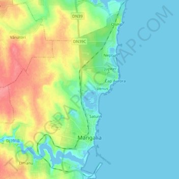
Name: Mangalia topographic map, elevation, terrain.
Location: Mangalia, Constanța, Romania (43.79498 28.49830 43.90039 28.61770)
Average elevation: 18 m
Minimum elevation: -3 m
Maximum elevation: 67 m
Make a donation
Other topographic maps
Click on a map to view its topography, its elevation and its terrain.
Dobrogea
Except for the Danube Delta, a marshy region located in its northeastern corner, Dobruja is hilly, with an average altitude of about 200–300 metres. The highest point is the Țuțuiatu (Greci) Peak in the Măcin Mountains, having a height of 467 m. The Dobruja Plateau covers most of the Romanian part of…
Average elevation: 53 m
Make a donation
Make a donation