
Make a donation
Labuerda topographic map
Click on the map to display elevation.
Make a donation
About this map
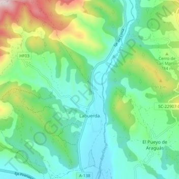
Name: Labuerda topographic map, elevation, terrain.
Location: Labuerda, Sobrarbe, Huesca, Aragón, 22360, España (42.43088 0.08501 42.48504 0.14175)
Average elevation: 710 m
Minimum elevation: 538 m
Maximum elevation: 1,180 m
Make a donation
Other topographic maps
Click on a map to view its topography, its elevation and its terrain.
Río Ebro
España > Aragón > Ribera Alta del Ebro > Torres de Berrellén
Tradicionalmente se ha considerado que el Ebro nace en Fontibre (del latín Fontes Hiberis o fuentes del Ebro), manantial situado a 880 m s. n. m. de altitud en la Hermandad de Campoo de Suso, en Cantabria.
Average elevation: 234 m
Make a donation
Albarracín
España > Aragón > Sierra de Albarracín > Albarracín > Albarracín
Average elevation: 1,302 m
Monte Perdido
Monte Perdido es el macizo calcáreo más alto de Europa. Se encuentra situado dentro de la vertiente sur del Pirineo central, al norte de la provincia de Huesca, en el parque nacional de Ordesa y Monte Perdido, en la comunidad autónoma de Aragón (España). Su pico más elevado es el Monte Perdido, con una…
Average elevation: 2,806 m
Make a donation
Cerler
Cerler (Sarllé en aragonés benasqués) es una localidad perteneciente al municipio de Benasque considerado el pueblo más alto del Pirineo aragonés por hallarse enclavado a 1540 metros de altitud, delante de Villarrué (1534 m s. n. m.) en el municipio de Laspaúles, según el Instituto Geográfico Nacional.
Average elevation: 1,601 m
Make a donation
Peralta de la Sal
Peralta de la Sal es una localidad española integrante del municipio de Peralta de Calasanz, en la Litera, provincia de Huesca (Aragón). Está situada bajo los barrancos de Calasanz y Gabasa, a la orilla del río Sosa, a 523 m de altitud. Con 142 de habitantes (INE 2022). El término confina por el Norte con…
Average elevation: 588 m
Make a donation
Make a donation
Make a donation
Make a donation
Pico Aneto
El Aneto es el pico más elevado de los Pirineos y el segundo más alto de la península ibérica, con una altitud de 3404 metros sobre el nivel del mar. Se encuentra situado en el Parque natural Posets-Maladeta, en el municipio español de Benasque, provincia de Huesca, comunidad autónoma de Aragón.
Average elevation: 2,925 m
Make a donation
Parque Natural Posets-Maladeta
España > Aragón > La Ribagorza
La vida se escalona según la altura y las condiciones ambientales. A menor altitud nos encontramos serbales, avellanos y abedules, en las laderas más húmedas aparecen hayas, pinos y abetos, y en las cotas más altas el pino silvestre da paso al pino negro. Entre esta vegetación se cobija una variada fauna.…
Average elevation: 1,897 m
Sistema Ibérico
España > Aragón > Tarazona y el Moncayo > Tarazona
El sistema Ibérico es un sistema montañoso de altitud media ubicada en el interior de la península ibérica, en España. Algunos de sus picos más altos son el Moncayo (2315 m s. n. m.), su cumbre de mayor altitud, el monte San Lorenzo (2271 m s. n. m.), el pico de Urbión (2228 m s. n. m.), el…
Average elevation: 1,906 m
Make a donation
Make a donation
Make a donation
Make a donation
Make a donation
Make a donation
La Virgen de la Vega
España > Aragón > Gúdar-Javalambre > Alcalá de la Selva
Average elevation: 1,479 m
Make a donation
Alastuey
España > Aragón > La Jacetania > Bailo
Se trata de un reducido caserío de origen medieval integrado en el municipio de Bailo. Situado en las estribaciones occidentales de la Sierra de San Juan de la Peña en un cerro a 826 m de altitud y organizado en torno a una plaza con un pozo comunal convertido en fuente.
Average elevation: 833 m
Make a donation
Make a donation
Make a donation
Make a donation
Make a donation
Río Ebro
España > Aragón > Ribera Alta del Ebro > Luceni
Tradicionalmente se ha considerado que el Ebro nace en Fontibre (del latín Fontes Hiberis o fuentes del Ebro), manantial situado a 880 m s. n. m. de altitud en la Hermandad de Campoo de Suso, en Cantabria.
Average elevation: 223 m
Make a donation
Zaragoza
En la ribera y en el área urbana, el terreno es llano por lo general, sobre todo en la parte norte de la ciudad asentada en la margen derecha de la desembocadura del río Gállego, mientras que la sur tiene una inclinación más pronunciada conforme se aleja del Ebro. La altura del río Ebro a su paso por…
Average elevation: 310 m
Huesca
Por Huesca discurre el río Isuela y también en sus alrededores el río Flumen, además se encuentra en el límite de las sierras exteriores del Pirineo. Desde la ciudad se puede ver la sierra de Guara, cuya cima llega a los 2077 m de altitud; por eso también es conocida como "la puerta de los Pirineos".
Average elevation: 589 m
Make a donation
Rubielos de Mora
España > Aragón > Gúdar-Javalambre > Rubielos de Mora > Rubielos de Mora
Average elevation: 979 m
La Puebla de Castro
España > Aragón > La Ribagorza > La Puebla de Castro > La Puebla de Castro
Average elevation: 581 m
Make a donation
Make a donation
Make a donation