
Le Moulin topographic map
Interactive map
Click on the map to display elevation.
About this map
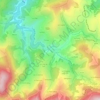
Name: Le Moulin topographic map, elevation, terrain.
Average elevation: 536 m
Minimum elevation: 326 m
Maximum elevation: 801 m
Other topographic maps
Click on a map to view its topography, its elevation and its terrain.
La Croix du Sud
France > Auvergne-Rhône-Alpes > Loire > Sainte-Croix-en-Jarez
La Croix du Sud, Sainte-Croix-en-Jarez, Saint-Étienne, Loire, Auvergne-Rhône-Alpes, France métropolitaine, 42800, France
Average elevation: 571 m
Rochassieux
France > Auvergne-Rhône-Alpes > Loire > Sainte-Croix-en-Jarez
Rochassieux, Sainte-Croix-en-Jarez, Saint-Étienne, Loire, Auvergne-Rhône-Alpes, France métropolitaine, 42800, France
Average elevation: 517 m
Thezay
France > Auvergne-Rhône-Alpes > Loire > Sainte-Croix-en-Jarez
Thezay, Sainte-Croix-en-Jarez, Saint-Étienne, Loire, Auvergne-Rhône-Alpes, France métropolitaine, 42800, France
Average elevation: 518 m