
Make a donation
Capitola topographic map
Click on the map to display elevation.
Make a donation
About this map
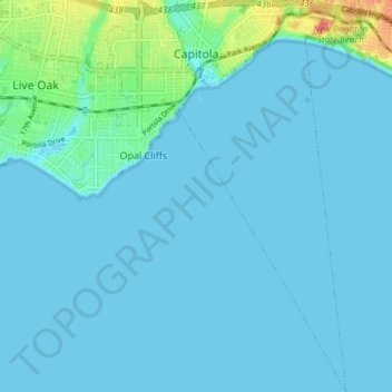
Name: Capitola topographic map, elevation, terrain.
Average elevation: 6 m
Minimum elevation: 0 m
Maximum elevation: 56 m
Make a donation
Other topographic maps
Click on a map to view its topography, its elevation and its terrain.
Make a donation
Live Oak
United States > California > Santa Cruz County > Live Oak
Live Oak is a census-designated place (CDP) in Santa Cruz County, California between the cities of Santa Cruz and Capitola and north of the former Union Pacific railroad. Live Oak sits at an elevation of 102 feet (31 m). The population was 17,038 at the 2020 census. The population of the greater Live Oak area,…
Average elevation: 47 m
Shangri La Estates
United States > California > Santa Cruz County > Pleasure Point
Average elevation: 12 m
Make a donation
Make a donation
Make a donation
Make a donation
Australian Garden
United States > California > Santa Cruz County > Santa Cruz
Average elevation: 131 m
Make a donation
Huckleberry Woods
United States > California > Santa Cruz County > Boulder Creek
Average elevation: 263 m
Make a donation
Make a donation