
Maria Neustift topographic map
Interactive map
Click on the map to display elevation.
Maria Neustift
Hauptort der Gemeinde ist das Dorf Maria Neustift. Es befindet sich 19 Kilometer südöstlich von Steyr und 13 km südwestlich von Waidhofen an der Ybbs. Es liegt auf einem Riedel zwischen dem Neustiftgraben im Süden und dem Höllgraben im Norden, auf um die 610 m ü. A. Höhe. Der Ort umfasst gut 110 Adressen. Er gehört zur Katastralgemeinde Buchschachen.
About this map
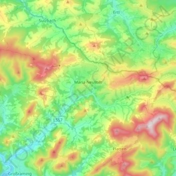
Name: Maria Neustift topographic map, elevation, terrain.
Average elevation: 634 m
Minimum elevation: 371 m
Maximum elevation: 1,092 m
Other topographic maps
Click on a map to view its topography, its elevation and its terrain.
Kleinraming
Österreich > Oberösterreich > Bezirk Steyr-Land > St. Ulrich bei Steyr
Average elevation: 513 m
Bodenwies
Österreich > Oberösterreich > Bezirk Steyr-Land > Weyer
Die Bodenwies ist mit 1540 m ü. A. Höhe der höchste Berg des Dürrensteigkamms, des östlichsten Teils der Oberösterreichischen Voralpen.
Average elevation: 1,123 m