
Managua topographic map
Interactive map
Click on the map to display elevation.
Managua
Managua's city area extends about 544 square kilometers (210 square miles), essentially south from the south shore of Lake Managua. The lakeshore is at an altitude of 55 meters (180 feet) above sea level, and the city climbs as it gets towards the Sierras de Managua further south where it is over 700 meters (2,297 feet) above sea level.
About this map
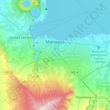
Name: Managua topographic map, elevation, terrain.
Location: Managua, 10000 (codigo maestro), Nicaragua (12.02118 -86.39185 12.22427 -86.12571)
Average elevation: 223 m
Minimum elevation: 36 m
Maximum elevation: 937 m
Other topographic maps
Click on a map to view its topography, its elevation and its terrain.
Managua
Managua, due to its tropical climate, varied topography, naturally fertile soils, and abundant rain and water sources, boasts a great variety of flora. Many different types of trees, some of which are not found elsewhere in the world, appear, including chilamates, ceibos, pochotes, genízaros, tigüilotes,…
Average elevation: 194 m