
Thank you for supporting this site ❤️
Make a donation
Make a donation
Luxembourg topographic map
Click on the map to display elevation.
Thank you for supporting this site ❤️
Make a donation
Make a donation
About this map
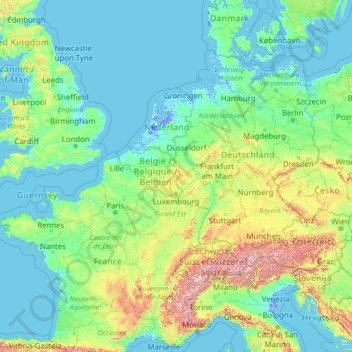
Name: Luxembourg topographic map, elevation, terrain.
Location: Luxembourg (42.81587 -0.87032 56.81587 13.12968)
Average elevation: 229 m
Minimum elevation: -6 m
Maximum elevation: 3,738 m
Thank you for supporting this site ❤️
Make a donation
Make a donation
Other topographic maps
Click on a map to view its topography, its elevation and its terrain.
Thank you for supporting this site ❤️
Make a donation
Make a donation
Contern
Luxembourg > Canton Luxembourg
Contern lies within the Guttland region of Luxembourg and covers part of both the Luxembourg Plateau and Moselle Valley sub-regions. The contrast between the two sub regions gives Contern a varying topography, from the rolling hills in the south, north and west to the sharp sandstone cliffs to the east around…
Average elevation: 307 m
Thank you for supporting this site ❤️
Make a donation
Make a donation
Thank you for supporting this site ❤️
Make a donation
Make a donation
Thank you for supporting this site ❤️
Make a donation
Make a donation
Thank you for supporting this site ❤️
Make a donation
Make a donation
Thank you for supporting this site ❤️
Make a donation
Make a donation
Thank you for supporting this site ❤️
Make a donation
Make a donation