
Thank you for supporting this site ❤️
Make a donation
Make a donation
Mathurata topographic map
Click on the map to display elevation.
Thank you for supporting this site ❤️
Make a donation
Make a donation
About this map
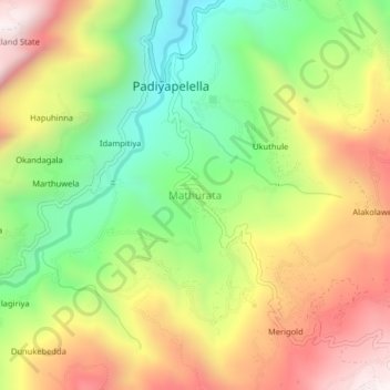
Name: Mathurata topographic map, elevation, terrain.
Location: Mathurata, Nuwara Eliya District, Central Province, Sri Lanka (7.05991 80.78152 7.09991 80.82152)
Average elevation: 1,056 m
Minimum elevation: 600 m
Maximum elevation: 1,574 m
Thank you for supporting this site ❤️
Make a donation
Make a donation
Other topographic maps
Click on a map to view its topography, its elevation and its terrain.
Thank you for supporting this site ❤️
Make a donation
Make a donation
upper division, north meddecombra
Sri Lanka > Central Province > upper division, north meddecombra
Average elevation: 1,268 m