
Menzel Temime topographic map
Interactive map
Click on the map to display elevation.
About this map
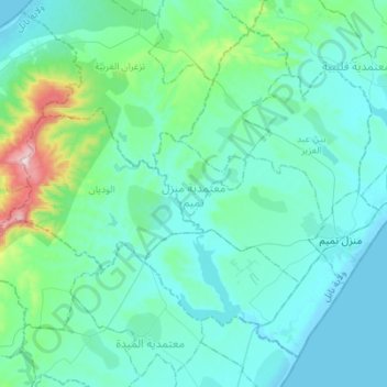
Name: Menzel Temime topographic map, elevation, terrain.
Location: Menzel Temime, Nabeul, 8080, Tunisie (36.71275 10.75795 36.90001 11.03331)
Average elevation: 82 m
Minimum elevation: -2 m
Maximum elevation: 632 m
Other topographic maps
Click on a map to view its topography, its elevation and its terrain.
Menzel Bou Zelfa
Tunisie > Nabeul > Menzel Bou Zelfa
Menzel Bou Zelfa, Menzel Bouzelfa Sud, Menzel Bouzelfa, Nabeul, 8010, Tunisie
Average elevation: 47 m
Bir Challouf
Tunisie > Nabeul > Bir Challouf
Bir Challouf, Neapolis, Nabeul, 8000, Tunisie
Average elevation: 15 m