
Make a donation
Kultali topographic map
Click on the map to display elevation.
Make a donation
Kultali
The Kultali CD block is located at 22°05′12″N 88°35′37″E / 22.0866°N 88.5937°E / 22.0866; 88.5937. It has an average elevation of 7 metres (23 ft).
Make a donation
About this map
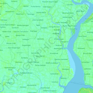
Name: Kultali topographic map, elevation, terrain.
Location: Kultali, South 24 Parganas District, West Bengal, India (22.00609 88.51788 22.21812 88.63014)
Average elevation: 3 m
Minimum elevation: -2 m
Maximum elevation: 10 m
Make a donation
Other topographic maps
Click on a map to view its topography, its elevation and its terrain.
Durgapur
India > West Bengal > Faridpur Durgapur
Durgapur is located at 23°33′N 87°19′E / 23.55°N 87.32°E / 23.55; 87.32. It has an average elevation of 65 metres (213 ft).
Average elevation: 76 m
Make a donation
Maheshtala
India > West Bengal > Thakurpukur Maheshtala
Maheshtala is located at 22°30′31″N 88°15′12″E / 22.5086210°N 88.2532182°E / 22.5086210; 88.2532182. It has an average elevation of 9 metres (30 ft).
Average elevation: 5 m
Make a donation
Sriniketan
India > West Bengal > Bolpur Sriniketan
Sriniketan has an average elevation of 49 metres (161 ft).
Average elevation: 53 m
Make a donation
Bally
India > West Bengal > Bally Jagachha
Bally is located at 22°39′N 88°20′E / 22.65°N 88.34°E / 22.65; 88.34 and also the northernmost part of Howrah city. It has an average elevation of 15 metres (49 feet). It is more elevated in the west than the east (where flows the Hoogly river), thus leading to a problem of water logging.…
Average elevation: 6 m
Ilam Bazar
India > West Bengal > Illambazar
Ilambazar is located at 23°38′N 87°32′E / 23.63°N 87.53°E / 23.63; 87.53. It has an average elevation of 54 m (177 ft).
Average elevation: 58 m
Make a donation
Chittaranjan
India > West Bengal > Salanpur
Chittaranjan is located at 23°52′N 86°52′E / 23.87°N 86.87°E / 23.87; 86.87. It has an average elevation of 155 metres (508 feet).
Average elevation: 156 m
Make a donation
Jaynagar Majilpur
India > West Bengal > Jaynagar - I
Jaynagar Majilpur is located at 22°10′31″N 88°25′12″E / 22.1751965°N 88.4200762°E / 22.1751965; 88.4200762. It has an average elevation of 8 metres (26 ft).
Average elevation: 5 m
Rajpur Sonarpur
India > West Bengal > Sonarpur
Rajpur Sonarpur is located at 22°26′18″N 88°25′55″E / 22.4382026°N 88.4320450°E / 22.4382026; 88.4320450. It has an average elevation of 9 metres (30 ft).
Average elevation: 4 m
Make a donation
Make a donation
Arambagh
India > West Bengal > Arambag
Arambagh is located at 22°53′N 87°47′E / 22.88°N 87.78°E / 22.88; 87.78. It has an average elevation of 15 metres (118 feet). The town is situated on the link Road (state highway-2) 81Km north-west of Kolkata, 27 Km north-west of Tarakeswar, 39 Km south-east of Bardhaman. It is located on the…
Average elevation: 17 m
Krishnanagar
India > West Bengal > Krishnagar-I
Krishnanagar is located at 23°24′N 88°30′E / 23.4°N 88.5°E / 23.4; 88.5. The area of the municipality is around 16 km2. It is situated on the southern banks of the Jalangi River. It has an average elevation of 14 metres (46 ft). The Tropic of Cancer passes through the outskirts of…
Average elevation: 11 m
Ashoknagar Kalyangarh
India > West Bengal > Habra - II
Ashoknagar is located at 22°49′59″N 88°37′59″E / 22.833°N 88.633°E / 22.833; 88.633. It is situated in the World's largest delta, The Ganga-Brahmaputra Delta. The elevation of Ashoknagar Kalyangarh from sea-level is 8 meters. There are many forest, several lakes, some canals and vast green…
Average elevation: 7 m
Make a donation
Kumarun Purba Barddhaman, West Bengal,713121
India > West Bengal > Bhatar > Kumarun Purba Barddhaman, West Bengal,713121
Average elevation: 36 m
Make a donation
Haldia
India > West Bengal > Haldia > Haldia
Haldia is located at 22°02′N 88°04′E / 22.03°N 88.06°E / 22.03; 88.06. It has an average elevation of 8 metres (26 ft).
Average elevation: 3 m
Kurseong
India > West Bengal > Kurseong Subdivision
Located at an altitude of 1,482.55 metres (4,864.0 ft), Kurseong is 32 kilometres (20 mi) from Darjeeling and has a pleasant climate throughout the year.
Average elevation: 1,127 m
Make a donation
Purulia
India > West Bengal > Purulia - II
Purulia is located at 23°20′N 86°22′E / 23.33°N 86.37°E / 23.33; 86.37. It has an average elevation of 228 metres (748 feet).
Average elevation: 241 m
Bardhaman
India > West Bengal > Burdwan - I
The region has an average elevation of 40 metres (131 ft). The city is situated 1100 km from New Delhi and a little less than 100 km north-west of Kolkata on the Grand Trunk Road (National Highway 19) and Eastern Railway. The chief rivers are the Damodar and the Banka.
Average elevation: 31 m
Make a donation
Shantipur
India > West Bengal > Santipur
Santipur is located at 23°15′N 88°26′E / 23.25°N 88.43°E / 23.25; 88.43. It has an average elevation of 15 metres (49 feet).
Average elevation: 11 m