
Thank you for supporting this site ❤️
Make a donation
Make a donation
Kisumu topographic map
Click on the map to display elevation.
Thank you for supporting this site ❤️
Make a donation
Make a donation
Kisumu
Its elevation is 1,131 m (3,711 ft) above sea level. Kisumu is about 320 km (200 mi) northwest of Nairobi and is located on the shores of Lake Victoria. It lies at the northeastern edge of the Winam Gulf, a long, shallow arm that protrudes from the main body of Lake Victoria. Kisumu is 24 km (15 mi) south of the equator and has, due to its elevation, moderate temperatures.
Thank you for supporting this site ❤️
Make a donation
Make a donation
About this map
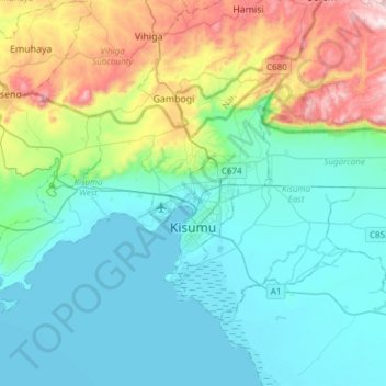
Name: Kisumu topographic map, elevation, terrain.
Location: Kisumu, City of Kisumu, Kisumu County, Nyanza, 40100, Kenya (-0.17522 34.57992 0.02263 34.88231)
Average elevation: 1,310 m
Minimum elevation: 1,131 m
Maximum elevation: 1,930 m
Thank you for supporting this site ❤️
Make a donation
Make a donation
Other topographic maps
Click on a map to view its topography, its elevation and its terrain.