Geolocate

Southern Province topographic map

Interactive map

Click on the map to display elevation.

About this map

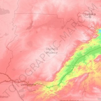
Name: Southern Province topographic map, elevation, terrain.

Location: Southern Province, Zambia (-18.07621 24.97167 -15.26662 28.92595)

Average elevation: 1,007 m

Minimum elevation: 420 m

Maximum elevation: 1,492 m

Southern Province is bordered along Zimbabwe in the south divided by Victoria Falls, Central in the north, Western Province in the west and Lusaka Province in the northeast. The general topography of the province is characterized by uplifted planation surfaces. The general elevation of the nation as a whole is tended towards West to East from the Kalahari Basin. The level of land falls from the upper Congo towards the Zambezi depression in the South forming a plateau.

Wikipedia (CC-BY-SA 3.0)

Other topographic maps

Click on a map to view its topography, its elevation and its terrain.

North-Western Province

Zambia

North-Western Province, Zambia

Average elevation: 1,199 m

Lusaka Province

Zambia

Lusaka Province, Zambia

Average elevation: 866 m

Western Province

Zambia

Western Province, Zambia

Average elevation: 1,069 m

Kasempa

Zambia > North-Western Province

Kasempa, Kasempa District, North-Western Province, Zambia

Average elevation: 1,251 m

Central Province

Zambia

Central Province, Zambia

Average elevation: 1,059 m

Mansa

Zambia > Luapula Province

Mansa, Mansa District, Luapula Province, Zambia

Average elevation: 1,218 m

South Luangwa National Park

Zambia > Muchinga Province

South Luangwa National Park, Muchinga Province, Zambia

Average elevation: 854 m

Mansa District

Zambia > Luapula Province

Mansa District, Luapula Province, Zambia

Average elevation: 1,193 m

Mpika

Zambia > Muchinga Province > Mpika

Mpika, Mpika District, Muchinga Province, Zambia

Average elevation: 1,356 m

Lake Kariba

Zambia > Southern Province

Lake Kariba, Southern Province, Zambia

Average elevation: 854 m

Victoria Falls

Zambia > Southern Province > Livingstone

Victoria Falls, Livingstone, Southern Province, Zambia

Average elevation: 877 m

Lake Mweru

Zambia > Luapula Province

Lake Mweru, Luapula Province, Zambia

Average elevation: 1,022 m

Chambeshi

Zambia > Muchinga Province > Chambeshi

Chambeshi, Muchinga Province, Zambia

Average elevation: 1,192 m