
Kerewan topographic map
Interactive map
Click on the map to display elevation.
About this map
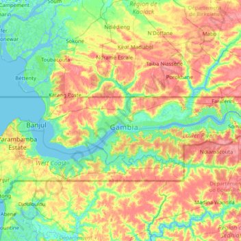
Name: Kerewan topographic map, elevation, terrain.
Location: Kerewan, Division de North Bank, Gambie (13.30321 -16.56027 13.64364 -15.30172)
Average elevation: 18 m
Minimum elevation: -3 m
Maximum elevation: 49 m
Other topographic maps
Click on a map to view its topography, its elevation and its terrain.
Lower Niumi
Gambie > Division de North Bank
Lower Niumi, Kerewan, Division de North Bank, Gambie
Average elevation: 19 m
Essau
Gambie > Division de North Bank > Essau
Essau, Lower Niumi, Kerewan, Division de North Bank, Gambie
Average elevation: 4 m
Niumi National Park
Gambie > Division de North Bank > Njongon
Niumi National Park, TAH 7, Essau, Njongon, Lower Niumi, Kerewan, Division de North Bank, Gambie
Average elevation: 6 m