
Thank you for supporting this site ❤️
Make a donation
Make a donation
Morgan Hill topographic map
Click on the map to display elevation.
Thank you for supporting this site ❤️
Make a donation
Make a donation
Morgan Hill
Morgan Hill is approximately 24 mi (39 km) south of downtown San Jose, 13 mi (21 km) north of Gilroy, and 15 mi (24 km) inland from the Pacific coast. Lying in a roughly 4-mile-wide (6 km) southern extension of the Santa Clara Valley, it is bounded by the Santa Cruz Mountains to the west and the Diablo Range to the east. At the valley floor, Morgan Hill lies at an elevation of about 350 feet (107 m) above MSL.
Thank you for supporting this site ❤️
Make a donation
Make a donation
About this map
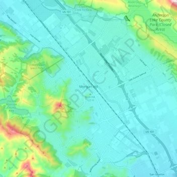
Name: Morgan Hill topographic map, elevation, terrain.
Average elevation: 153 m
Minimum elevation: 78 m
Maximum elevation: 502 m
Thank you for supporting this site ❤️
Make a donation
Make a donation
Other topographic maps
Click on a map to view its topography, its elevation and its terrain.
Sierra Vista Open Space Preserve
United States > California > Santa Clara County > San Jose
Average elevation: 484 m