
Make a donation
Lago Sul topographic map
Click on the map to display elevation.
Make a donation
About this map
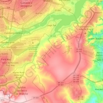
Name: Lago Sul topographic map, elevation, terrain.
Location: Lago Sul, Federal District, Central-West Region, Brazil (-15.98396 -47.98373 -15.79233 -47.78593)
Average elevation: 1,076 m
Minimum elevation: 893 m
Maximum elevation: 1,214 m
Make a donation
Other topographic maps
Click on a map to view its topography, its elevation and its terrain.
Brasília
The city sits at an elevation of 1,000 metres (3,300 ft) and more, high on the Brazilian Highlands in the country's center-western region. Paranoá Lake, a large artificial lake, was built to increase the amount of water available and to maintain the region's humidity. It has a marina, and hosts wakeboarders…
Average elevation: 1,084 m
Brasília
Brazil > Federal District > Região Integrada de Desenvolvimento do Distrito Federal e Entorno
The city sits at an elevation of 1,000 metres (3,300 ft) and more, high on the Brazilian Highlands in the country's center-western region. Paranoá Lake, a large artificial lake, was built to increase the amount of water available and to maintain the region's humidity. It has a marina, and hosts wakeboarders…
Average elevation: 1,084 m
Condominio Verde Perto
Brazil > Federal District > Região Integrada de Desenvolvimento do Distrito Federal e Entorno > Guará
Average elevation: 1,099 m