
Fernão Ferro topographic map
Interactive map
Click on the map to display elevation.
About this map
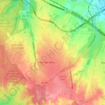
Name: Fernão Ferro topographic map, elevation, terrain.
Location: Fernão Ferro, Seixal, Setúbal, Portugal (38.54068 -9.12811 38.60168 -9.04852)
Average elevation: 49 m
Minimum elevation: -1 m
Maximum elevation: 85 m
Other topographic maps
Click on a map to view its topography, its elevation and its terrain.
Casal do Marco
Casal do Marco, Seixal, Arrentela e Aldeia de Paio Pires, Seixal, Setúbal, 2840-183, Portugal
Average elevation: 24 m
Fernão Ferro
Portugal > Setúbal > Seixal > Fernão Ferro
Fernão Ferro, Seixal, Setúbal, 2865-601, Portugal
Average elevation: 61 m