
เกาะพีพีดอน topographic map
Interactive map
Click on the map to display elevation.
About this map
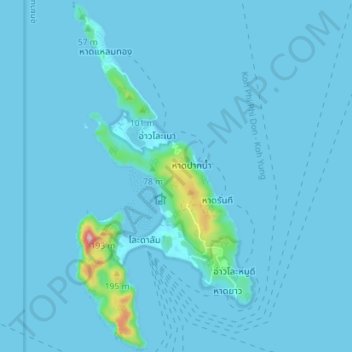
Name: เกาะพีพีดอน topographic map, elevation, terrain.
Location: เกาะพีพีดอน, จังหวัดกระบี่, Thaïlande (7.71735 98.75551 7.78749 98.79225)
Average elevation: 11 m
Minimum elevation: 0 m
Maximum elevation: 274 m
Other topographic maps
Click on a map to view its topography, its elevation and its terrain.
กระบี่
Thaïlande > จังหวัดกระบี่ > กระบี่
กระบี่, จังหวัดกระบี่, KRABI 81000, Thaïlande
Average elevation: 8 m