
Make a donation
Lexington County topographic map
Click on the map to display elevation.
Make a donation
Lexington County
According to the U.S. Census Bureau, the county has a total area of 757.62 square miles (1,962.2 km2), of which 699.00 square miles (1,810.4 km2) is land and 58.62 square miles (151.8 km2) (7.74%) is water. The largest body of water is Lake Murray, while other waterways include the Broad River, the Saluda River and the Congaree River. Lexington County has urban, suburban, and rural landscapes. Much of the county's urbanization is in its eastern and northeastern areas. The elevation in the county is 392 feet (119 m).
Make a donation
About this map
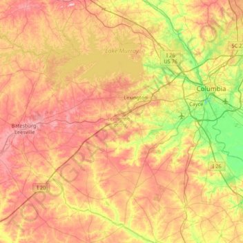
Name: Lexington County topographic map, elevation, terrain.
Location: Lexington County, South Carolina, United States (33.65359 -81.57516 34.19742 -80.92526)
Average elevation: 116 m
Minimum elevation: -6 m
Maximum elevation: 240 m
Make a donation
Other topographic maps
Click on a map to view its topography, its elevation and its terrain.
Florence
United States > South Carolina > Florence County > Florence
Florence is located in the coastal plain of South Carolina. It is in the northeastern part of the state and the northern part of Florence County. The average elevation above sea level is around 140 ft (43 m). Jeffries Creek is a tributary of the Great Pee Dee River and is the main waterway that flows through…
Average elevation: 35 m
Make a donation
Garden City Beach
United States > South Carolina > Horry County > Garden City Beach
Average elevation: 4 m