
Saint-Jouin-de-Marnes topographic map
Interactive map
Click on the map to display elevation.
About this map
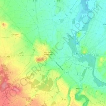
Name: Saint-Jouin-de-Marnes topographic map, elevation, terrain.
Average elevation: 79 m
Minimum elevation: 49 m
Maximum elevation: 134 m
Other topographic maps
Click on a map to view its topography, its elevation and its terrain.
Oiron
France > Nouvelle-Aquitaine > Deux-Sèvres > Plaine-et-Vallées
Oiron, Plaine-et-Vallées, Bressuire, Deux-Sèvres, Nouvelle-Aquitaine, France métropolitaine, 79100, France
Average elevation: 77 m
Ligaine
France > Nouvelle-Aquitaine > Deux-Sèvres > Plaine-et-Vallées
Ligaine, Taizé-Maulais, Plaine-et-Vallées, Bressuire, Deux-Sèvres, Nouvelle-Aquitaine, France métropolitaine, 79100, France
Average elevation: 83 m
Château
France > Nouvelle-Aquitaine > Deux-Sèvres > Plaine-et-Vallées
Château, Saint-Jouin-de-Marnes, Plaine-et-Vallées, Bressuire, Deux-Sèvres, Nouvelle-Aquitaine, France métropolitaine, 79600, France
Average elevation: 73 m
Brie
France > Nouvelle-Aquitaine > Deux-Sèvres > Plaine-et-Vallées
Brie, Plaine-et-Vallées, Bressuire, Deux-Sèvres, Nouvelle-Aquitaine, France métropolitaine, 79100, France
Average elevation: 61 m
Oiron
France > Nouvelle-Aquitaine > Deux-Sèvres > Plaine-et-Vallées > Oiron
Oiron, Plaine-et-Vallées, Bressuire, Deux-Sèvres, Nouvelle-Aquitaine, France métropolitaine, 79100, France
Average elevation: 81 m
Noizé
France > Nouvelle-Aquitaine > Deux-Sèvres > Plaine-et-Vallées
Noizé, Oiron, Plaine-et-Vallées, Bressuire, Deux-Sèvres, Nouvelle-Aquitaine, France métropolitaine, 79100, France
Average elevation: 83 m