
Bibern SH topographic map
Interactive map
Click on the map to display elevation.
About this map
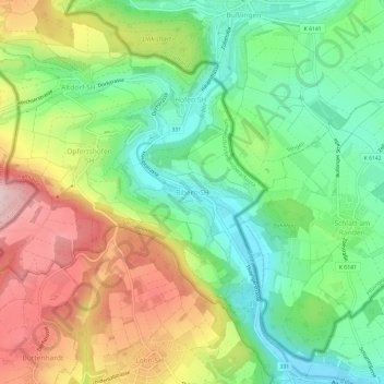
Name: Bibern SH topographic map, elevation, terrain.
Location: Bibern SH, Thayngen, Schaffhausen, 8242, Schweiz (47.75323 8.65700 47.79323 8.69700)
Average elevation: 555 m
Minimum elevation: 442 m
Maximum elevation: 720 m
Other topographic maps
Click on a map to view its topography, its elevation and its terrain.
Wannenhof
Schweiz > Schaffhausen > Beggingen
Wannenhof, Beggingen, Schaffhausen, 8228, Schweiz
Average elevation: 728 m
Stein am Rhein
Stein am Rhein, Schaffhausen, 8260, Schweiz
Average elevation: 474 m
Hallau
Schweiz > Schaffhausen > Bezirk Unterklettgau
Hallau, Bezirk Unterklettgau, Schaffhausen, 8215, Schweiz
Average elevation: 485 m
Neuhausen am Rheinfall
Neuhausen am Rheinfall, Schaffhausen, 8212, Schweiz
Average elevation: 450 m