
Thank you for supporting this site ❤️
Make a donation
Make a donation
Khadir Bet topographic map
Click on the map to display elevation.
Thank you for supporting this site ❤️
Make a donation
Make a donation
About this map
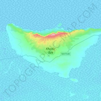
Name: Khadir Bet topographic map, elevation, terrain.
Location: Khadir Bet, Bhachau Taluka, Kachchh, Gujarat, India (23.78166 70.17084 23.94256 70.48736)
Average elevation: 14 m
Minimum elevation: -6 m
Maximum elevation: 276 m
Thank you for supporting this site ❤️
Make a donation
Make a donation
Other topographic maps
Click on a map to view its topography, its elevation and its terrain.