
Thank you for supporting this site ❤️
Make a donation
Make a donation
St. Mary's topographic map
Click on the map to display elevation.
Thank you for supporting this site ❤️
Make a donation
Make a donation
About this map
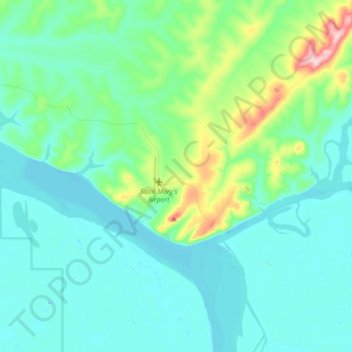
Name: St. Mary's topographic map, elevation, terrain.
Average elevation: 40 m
Minimum elevation: -8 m
Maximum elevation: 265 m
Thank you for supporting this site ❤️
Make a donation
Make a donation
Other topographic maps
Click on a map to view its topography, its elevation and its terrain.
Lituya Glacier
United States > Alaska > Unorganized Borough
It is partially responsible for creating the 1958 Lituya Bay megatsunami. The glacier, which has receded over the years, carved Lituya Bay into a unique topographic phenomenon with steep walls, a very deep submerged bottom, and a very narrow entrance to the ocean which created the opportunity for a megatsunami…
Average elevation: 952 m