Koregaon topographic map
Interactive map
Click on the map to display elevation.
About this map
![Koregaon topographic map, elevation, terrain](/pub/maps/node/tstj/c1vcf4s/thumbnail.jpg)
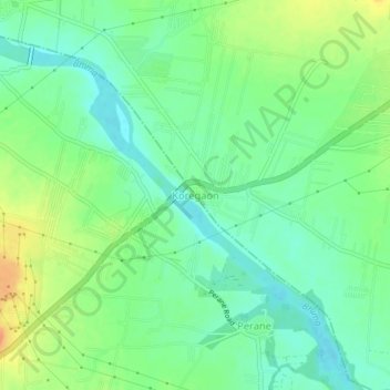
Name: Koregaon topographic map, elevation, terrain.
Location: Koregaon, Shirur, Maharashtra, 412216, India (18.62525 74.03794 18.66525 74.07794)
Average elevation: 553 m
Minimum elevation: 537 m
Maximum elevation: 579 m
Other topographic maps
Click on a map to view its topography, its elevation and its terrain.
![Pabal topographic map, elevation, terrain](/pub/maps/node/fj4s/b3w9kzs/icon.jpg)
Pabal
India > Maharashtra > Shirur
Pabal, Shirur, Pune, Maharashtra, 412403, India
Average elevation: 681 m
![Sarawadi topographic map, elevation, terrain](/pub/maps/node/g4tf/nh4vz57/icon.jpg)
Sarawadi
India > Maharashtra > Shirur
Sarawadi, Shirur, Maharashtra, 412210, India
Average elevation: 604 m
![Shikrapur topographic map, elevation, terrain](/pub/maps/node/b2tf/nh4nx57/icon.jpg)
Shikrapur
India > Maharashtra > Shirur > Shikrapur
Shikrapur, Shirur, Pune District, Maharashtra, 412208, India
Average elevation: 581 m