
Thank you for supporting this site ❤️
Make a donation
Make a donation
Burns topographic map
Click on the map to display elevation.
Thank you for supporting this site ❤️
Make a donation
Make a donation
About this map
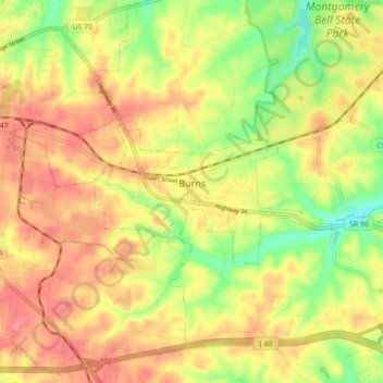
Name: Burns topographic map, elevation, terrain.
Location: Burns, Dickson County, Tennessee, United States (36.03848 -87.35040 36.06527 -87.26259)
Average elevation: 239 m
Minimum elevation: 187 m
Maximum elevation: 280 m
Thank you for supporting this site ❤️
Make a donation
Make a donation
Other topographic maps
Click on a map to view its topography, its elevation and its terrain.