
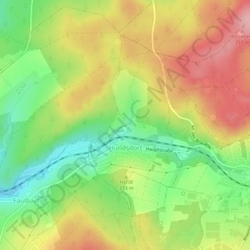
Hundsdorf topographic map
Interactive map
Click on the map to display elevation.
About this map
Name: Hundsdorf topographic map, elevation, terrain.
Average elevation: 325 m
Minimum elevation: 250 m
Maximum elevation: 403 m
Other topographic maps
Click on a map to view its topography, its elevation and its terrain.
Dreisbach
Duitsland > Rijnland-Palts > Westerwaldkreis
Dreisbach, Bad Marienberg (Westerwald), Westerwaldkreis, Rijnland-Palts, Duitsland
Average elevation: 443 m
Höhr-Grenzhausen
Duitsland > Rijnland-Palts > Westerwaldkreis > Höhr-Grenzhausen
Höhr-Grenzhausen, Westerwaldkreis, Rijnland-Palts, 56203, Duitsland
Average elevation: 295 m
Bellingen
Duitsland > Rijnland-Palts > Westerwaldkreis > Bellingen
Bellingen, Westerburg, Westerwaldkreis, Rijnland-Palts, Duitsland
Average elevation: 457 m
Ransbach-Baumbach
Duitsland > Rijnland-Palts > Westerwaldkreis > Ransbach-Baumbach
Ransbach-Baumbach, Westerwaldkreis, Rijnland-Palts, 56235, Duitsland
Average elevation: 349 m
Linden
Duitsland > Rijnland-Palts > Westerwaldkreis
Linden, Hachenburg, Westerwaldkreis, Rijnland-Palts, Duitsland
Average elevation: 453 m
Willingen
Duitsland > Rijnland-Palts > Westerwaldkreis
Willingen, Rennerod, Westerwaldkreis, Rijnland-Palts, Duitsland
Average elevation: 586 m