
Thank you for supporting this site ❤️
Make a donation
Make a donation
Gutmaning topographic map
Click on the map to display elevation.
Thank you for supporting this site ❤️
Make a donation
Make a donation
About this map
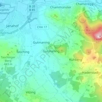
Name: Gutmaning topographic map, elevation, terrain.
Location: Gutmaning, Cham, Landkreis Cham, Bayern, 93413, Deutschland (49.17318 12.66941 49.21318 12.70941)
Average elevation: 412 m
Minimum elevation: 365 m
Maximum elevation: 592 m
Thank you for supporting this site ❤️
Make a donation
Make a donation
Other topographic maps
Click on a map to view its topography, its elevation and its terrain.