
Thank you for supporting this site ❤️
Make a donation
Make a donation
Lake Volta topographic map
Click on the map to display elevation.
Thank you for supporting this site ❤️
Make a donation
Make a donation
About this map
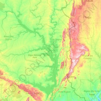
Name: Lake Volta topographic map, elevation, terrain.
Location: Lake Volta, Bono East Region, Ghana (6.24236 -1.19247 8.76335 0.32644)
Average elevation: 195 m
Minimum elevation: 7 m
Maximum elevation: 946 m
Thank you for supporting this site ❤️
Make a donation
Make a donation
Other topographic maps
Click on a map to view its topography, its elevation and its terrain.