
Make a donation
Adak topographic map
Click on the map to display elevation.
Make a donation
Adak
Because of its naval aviation past, Adak has an unusually large and sophisticated airport for the Aleutian Islands. The airport is currently operated by the State of Alaska Department of Transportation. Complete with an Instrument Landing System, Adak Airport has no control tower and two 200 ft (61 m) wide asphalt paved runways at 19 ft (5.8 m) elevation. One runway measures 7,790 ft (2,370 m) long while the other runway measures 7,605 ft (2,318 m). Alaska Airlines operates twice-weekly Boeing 737 passenger jet service from Anchorage. At present, flights operate each Wednesday and Saturday, weather permitting. Occasionally, extra seasonal flights are operated to meet the demand of the fishing season.
Make a donation
About this map
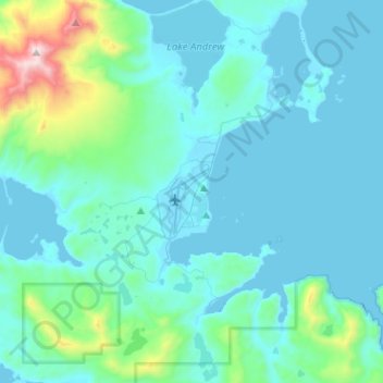
Name: Adak topographic map, elevation, terrain.
Location: Adak, Unorganized Borough, Alaska, 99546, United States (51.80081 -176.71310 51.95762 -176.46674)
Average elevation: 136 m
Minimum elevation: -8 m
Maximum elevation: 1,173 m
Make a donation
Other topographic maps
Click on a map to view its topography, its elevation and its terrain.
Kasatochi Island
United States > Alaska > Unorganized Borough
Kasatochi Island is a member of the Aleutian Islands, which lie above a narrow ridge that separates the Bering Sea from the North Pacific. It lies at the Atka Pass northwest of the western tip of Atka Island and east of Great Sitkin Island. It is at 52.177° N latitude and 175.508° W longitude, with a summit…
Average elevation: 53 m
Make a donation
Make a donation
Make a donation
Denali's Fault. Scenic overlook
United States > Alaska > Unorganized Borough > Delta Junction
Average elevation: 379 m
Make a donation