
Lengerich topographic map
Interactive map
Click on the map to display elevation.
About this map
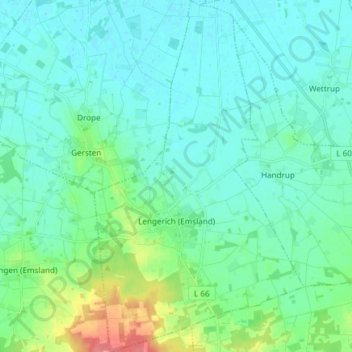
Name: Lengerich topographic map, elevation, terrain.
Average elevation: 33 m
Minimum elevation: 19 m
Maximum elevation: 91 m
Lengerich liegt am Nordostrand der Lingener Höhe etwa 15 km östlich der Ems und der Stadt Lingen.
Other topographic maps
Click on a map to view its topography, its elevation and its terrain.
Papenburg
Deutschland > Niedersachsen > Landkreis Emsland
Papenburg, Landkreis Emsland, Niedersachsen, 26871, Deutschland
Average elevation: 5 m