
Penhas topographic map
Interactive map
Click on the map to display elevation.
About this map
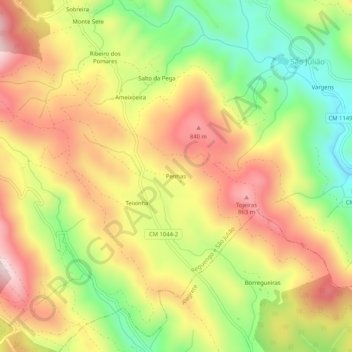
Name: Penhas topographic map, elevation, terrain.
Location: Penhas, Reguengo e São Julião, Portalegre, 7300-321, Portugal (39.27720 -7.33954 39.31720 -7.29954)
Average elevation: 678 m
Minimum elevation: 454 m
Maximum elevation: 888 m
Other topographic maps
Click on a map to view its topography, its elevation and its terrain.
São Julião
Portugal > Portalegre > Portalegre
São Julião, Portalegre, 7300-459, Portugal
Average elevation: 645 m
Reguengo e São Julião
Portugal > Portalegre > Portalegre
Reguengo e São Julião, Portalegre, Portugal
Average elevation: 602 m
Ribeira de Nisa
Portugal > Portalegre > Portalegre
Ribeira de Nisa, Portalegre, 7300-431, Portugal
Average elevation: 572 m
Ribeira de Nisa e Carreiras
Portugal > Portalegre > Portalegre
Ribeira de Nisa e Carreiras, Portalegre, Portugal
Average elevation: 526 m