
Villaseca topographic map
Interactive map
Click on the map to display elevation.
About this map
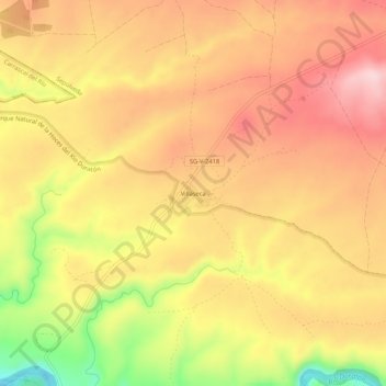
Name: Villaseca topographic map, elevation, terrain.
Location: Villaseca, Sepúlveda, Segovia, Castilla y León, España (41.29635 -3.84662 41.33635 -3.80662)
Average elevation: 1,031 m
Minimum elevation: 886 m
Maximum elevation: 1,119 m
Other topographic maps
Click on a map to view its topography, its elevation and its terrain.
Parque Natural de la Hoces del Río Duratón
España > Castilla y León > Sepúlveda
Parque Natural de la Hoces del Río Duratón, Sepúlveda, Segovia, Castilla y León, España
Average elevation: 988 m