
Vacaville topographic map
Interactive map
Click on the map to display elevation.
About this map
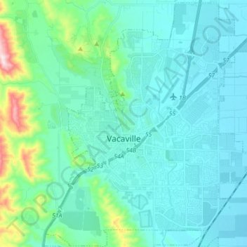
Name: Vacaville topographic map, elevation, terrain.
Average elevation: 90 m
Minimum elevation: 20 m
Maximum elevation: 496 m
Vacaville a pour coordonnées géographiques 38° 21′ 14″ N, 121° 58′ 22″ O (38° 21′ 14″ N, 121° 58′ 22″ O). La ville est à 53 m d'altitude. Elle est située entre San Francisco et Sacramento.
Other topographic maps
Click on a map to view its topography, its elevation and its terrain.
Fairfield
États-Unis d'Amérique > Californie > Solano County
Fairfield, Solano County, Californie, États-Unis d'Amérique
Average elevation: 59 m
Vallejo
États-Unis d'Amérique > Californie > Solano County
Vallejo, Solano County, Californie, États-Unis d'Amérique
Average elevation: 45 m