
Klyuchevskaya Sopka topographic map
Interactive map
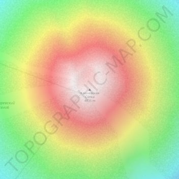
Click on the map to display elevation.
About this map
Name: Klyuchevskaya Sopka topographic map, elevation, terrain.
Average elevation: 4,140 m
Minimum elevation: 3,465 m
Maximum elevation: 4,761 m
As early as 27 February 2010, gas plumes had erupted from Klyuchevskaya Sopka (reaching elevations of 7,000 m (23,000 ft)) and during the first week of March 2010, both explosive ash eruptions and effusive lava eruptions occurred until, by 9 March, the ash cloud was reported to have reached an elevation of 6,000 m (20,000 ft). Also, significant thermal anomalies have been reported and gas-steam plumes extended roughly 50 km (31 mi) to the north-east from the volcano on 3 March.
Other topographic maps
Click on a map to view its topography, its elevation and its terrain.
Bystrinsky District
Bystrinsky District, Kamchatka Krai, Far Eastern Federal District, Russia
Average elevation: 582 m
Yelizovsky District
Yelizovsky District, Kamchatka Krai, Far Eastern Federal District, Russia
Average elevation: 191 m
Karaginsky Island
Karaginsky Island, Karaginsky District, Корякский округ, Kamchatka Krai, Far Eastern Federal District, Russia
Average elevation: 39 m
Кроноцкая сопка
Кроноцкая сопка, Yelizovsky District, Kamchatka Krai, Far Eastern Federal District, Russia
Average elevation: 2,683 m
Ust-Kamchatsky District
Ust-Kamchatsky District, Kamchatka Krai, Far Eastern Federal District, Russia
Average elevation: 305 m
Bering Island
Bering Island, Aleutsky District, Kamchatka Krai, Far Eastern Federal District, 684500, Russia
Average elevation: 30 m
Karaginsky District
Karaginsky District, Корякский округ, Kamchatka Krai, Far Eastern Federal District, 688700, Russia
Average elevation: 146 m
Aleutsky District
Aleutsky District, Kamchatka Krai, Far Eastern Federal District, 684500, Russia
Average elevation: 5 m