
จังหวัดเพชรบุรี topographic map
Interactive map
Click on the map to display elevation.
About this map
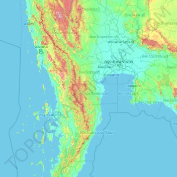
Name: จังหวัดเพชรบุรี topographic map, elevation, terrain.
Location: จังหวัดเพชรบุรี, Thaïlande (10.50929 97.04444 15.62929 102.16444)
Average elevation: 105 m
Minimum elevation: -2 m
Maximum elevation: 1,855 m
Other topographic maps
Click on a map to view its topography, its elevation and its terrain.
แก่งกระจาน
Thaïlande > จังหวัดเพชรบุรี > แก่งกระจาน
แก่งกระจาน, จังหวัดเพชรบุรี, Thaïlande
Average elevation: 95 m