
Make a donation
Kerman Province topographic map
Click on the map to display elevation.
Make a donation
Kerman Province
The altitudes and heights of the province are the continuation of the central mountain ranges of Iran. They extend from the volcanic folds beginning in Azerbaijan and, by branching out in the central plateau of Iran, terminate in Baluchestan. These mountain ranges have brought about vast plains in the province. The Bashagard and Kuhbonan Mountains are the highest in this region and include peaks such as Toghrol, Aljerd, Palvar, Sirach, Abareq and Tahrood. Other ranges that stretch out from Yazd to Kerman and Challeh-ye-Jazmoorian include high peaks like Hazaran which is 4,501 meters above sea level (ASL), Kuh-e Shah 4,402 meters ASL, Joupar, Bahr Aseman and Khabr mountain in Khabr National Park and others.
Make a donation
About this map
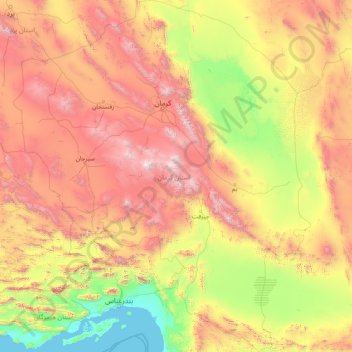
Name: Kerman Province topographic map, elevation, terrain.
Location: Kerman Province, Iran (26.44500 54.37031 31.95696 59.72550)
Average elevation: 1,150 m
Minimum elevation: -1 m
Maximum elevation: 4,224 m
Make a donation
Other topographic maps
Click on a map to view its topography, its elevation and its terrain.
Amlash
Iran > Gilan Province > Amlash County > دهستان املش شمالی
Amlash (Persian: املش) is a city in the Central District of Amlash County, Gilan province, in northwestern Iran, serving as the capital of both the county and the district. Amlash sits at an altitude of 13 metres (45 feet).
Average elevation: 66 m
Make a donation
Make a donation
پایین شالینگچال
Iran > Mazandaran Province > Babol County > دهستان فیروزجاه
Average elevation: 2,077 m
Make a donation
Make a donation
Make a donation
Sabalan
Iran > Ardabil Province > Meshkinshahr County > دهستان لاهرود
At 4,794 metres (15,728 ft) in elevation, it is the third-highest mountain in Iran. It has a permanent crater lake formed at its summit. On one of its slopes around 3,600 metres (11,800 ft) in elevation there are large rock formations of eroded volcanic outcrops that resemble animals, birds, and insects.
Average elevation: 4,281 m
Make a donation
Kashan
Iran > East Azerbaijan Province > دهستان گویجه بل > Kashan
Kashan has a cold desert climate with cold winters (although warmer than other Iranian cities) and hot, sometimes very hot summers. Kashan is significantly warmer than other cities in the Iranian Plateau due to its lower elevation. Its climate is somewhat similar to Qom.
Average elevation: 1,416 m
Make a donation
Bisotun
Iran > Kermanshah Province > Harsin County > دهستان چم چمال > Bisotun
Average elevation: 1,477 m
Beynaq, Razavi Khorasan
Iran > East Azerbaijan Province > Ahar County > دهستان اوچ هاچا > Beynaq, Razavi Khorasan
Average elevation: 1,599 m
Make a donation
Qinarjeh, Takab
Iran > West Azerbaijan Province > Takab County > Qinarjeh, Takab
Average elevation: 2,334 m
Make a donation
Zard Kuh
Iran > Chaharmahal and Bakhtiyari Province > Kuhrang County > شهریاری
Average elevation: 3,808 m
Make a donation