
Thank you for supporting this site ❤️
Make a donation
Make a donation
Dornbirn topographic map
Click on the map to display elevation.
Thank you for supporting this site ❤️
Make a donation
Make a donation
About this map
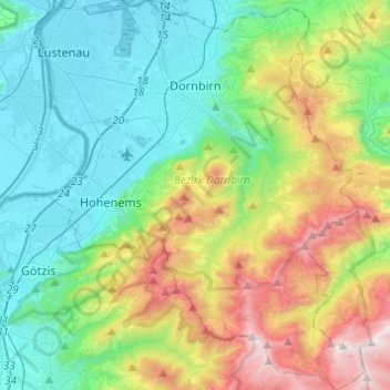
Name: Dornbirn topographic map, elevation, terrain.
Location: Dornbirn, Bezirk Dornbirn, Vorarlberg, Austria (47.28435 9.69194 47.44967 9.84862)
Average elevation: 874 m
Minimum elevation: 398 m
Maximum elevation: 2,035 m
Thank you for supporting this site ❤️
Make a donation
Make a donation
Other topographic maps
Click on a map to view its topography, its elevation and its terrain.