
Thank you for supporting this site ❤️
Make a donation
Make a donation
El Cenepa topographic map
Click on the map to display elevation.
Thank you for supporting this site ❤️
Make a donation
Make a donation
About this map
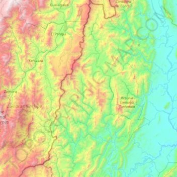
Name: El Cenepa topographic map, elevation, terrain.
Location: El Cenepa, Condorcanqui, Amazonas, Perú (-4.72105 -78.65262 -3.36746 -78.02728)
Average elevation: 1,053 m
Minimum elevation: 161 m
Maximum elevation: 3,681 m
Thank you for supporting this site ❤️
Make a donation
Make a donation
Other topographic maps
Click on a map to view its topography, its elevation and its terrain.
Thank you for supporting this site ❤️
Make a donation
Make a donation
Thank you for supporting this site ❤️
Make a donation
Make a donation