
Make a donation
Hamilton County topographic map
Click on the map to display elevation.
Make a donation
About this map
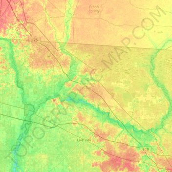
Name: Hamilton County topographic map, elevation, terrain.
Location: Hamilton County, Florida, United States (30.31724 -83.30980 30.63440 -82.64548)
Average elevation: 37 m
Minimum elevation: 11 m
Maximum elevation: 73 m
Make a donation
Other topographic maps
Click on a map to view its topography, its elevation and its terrain.
Tallahassee
United States > Florida > Leon County > Tallahassee
Tallahassee's terrain is hilly by Florida standards, being at the southern end of the Red Hills Region, just above the Cody Scarp. The elevation varies from near sea level to just over 200 feet (61 m), with the state capitol on one of the highest hills in the city. The city includes two large lake basins, Lake…
Average elevation: 32 m
Make a donation
Jupiter Inlet Light
United States > Florida > Palm Beach County > Jupiter
The Jupiter Inlet Light is located in Jupiter, Florida, on the north side of the Jupiter Inlet. The site for the lighthouse was chosen in 1853. It is located between Cape Canaveral Light and Hillsboro Inlet Light. The lighthouse was designed by then Lieutenant George G. Meade of the Bureau of Topographical…
Average elevation: 4 m
Make a donation
South Gulf Cove Park
United States > Florida > Charlotte County > Port Charlotte
Average elevation: 3 m
Make a donation
Make a donation
Make a donation
Lakeland Highlands
United States > Florida > Polk County > Bartow > Lakeland Highlands
Average elevation: 64 m
Make a donation
Lake Ella
United States > Florida > Leon County > Tallahassee
In 1986, Lake Ella underwent extensive rehabilitation including sediment removal, reshaping of the shoreline, reducing the number of stormwater inflow pipes, and installation of an automatic alum treatment system. Lake Ella receives stormwater runoff from an urban watershed that is approximately 157 acres…
Average elevation: 56 m
Hillsborough River Estates
United States > Florida > Hillsborough County > Tampa
Average elevation: 14 m
Make a donation
Make a donation
Make a donation
Make a donation
Make a donation
Bonita Landing
United States > Florida > Lee County > Bonita Springs > Bonita Landing
Average elevation: 6 m