
Thank you for supporting this site ❤️
Make a donation
Make a donation
Chakkittapara topographic map
Click on the map to display elevation.
Thank you for supporting this site ❤️
Make a donation
Make a donation
About this map
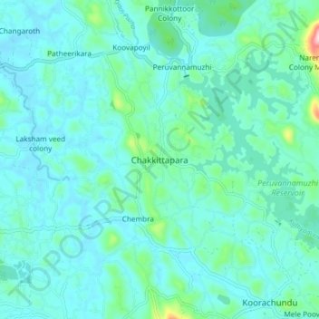
Name: Chakkittapara topographic map, elevation, terrain.
Location: Chakkittapara, Koyilandi, Kozhikode, Kerala, 673526, India (11.53547 75.77649 11.61547 75.85649)
Average elevation: 47 m
Minimum elevation: 6 m
Maximum elevation: 296 m
Thank you for supporting this site ❤️
Make a donation
Make a donation
Other topographic maps
Click on a map to view its topography, its elevation and its terrain.
Alangattu Vettkkoru makan kshethra Kulam at Cheliya
Average elevation: 13 m
Thank you for supporting this site ❤️
Make a donation
Make a donation
Thank you for supporting this site ❤️
Make a donation
Make a donation